If every European capital sent out a car at the same moment
Thirty-eight capitals, one start. Every place in Europe is coloured by the capital whose car gets there first — non-stop at typical road speeds, ferries included. The borders that come out are not the ones on the map.
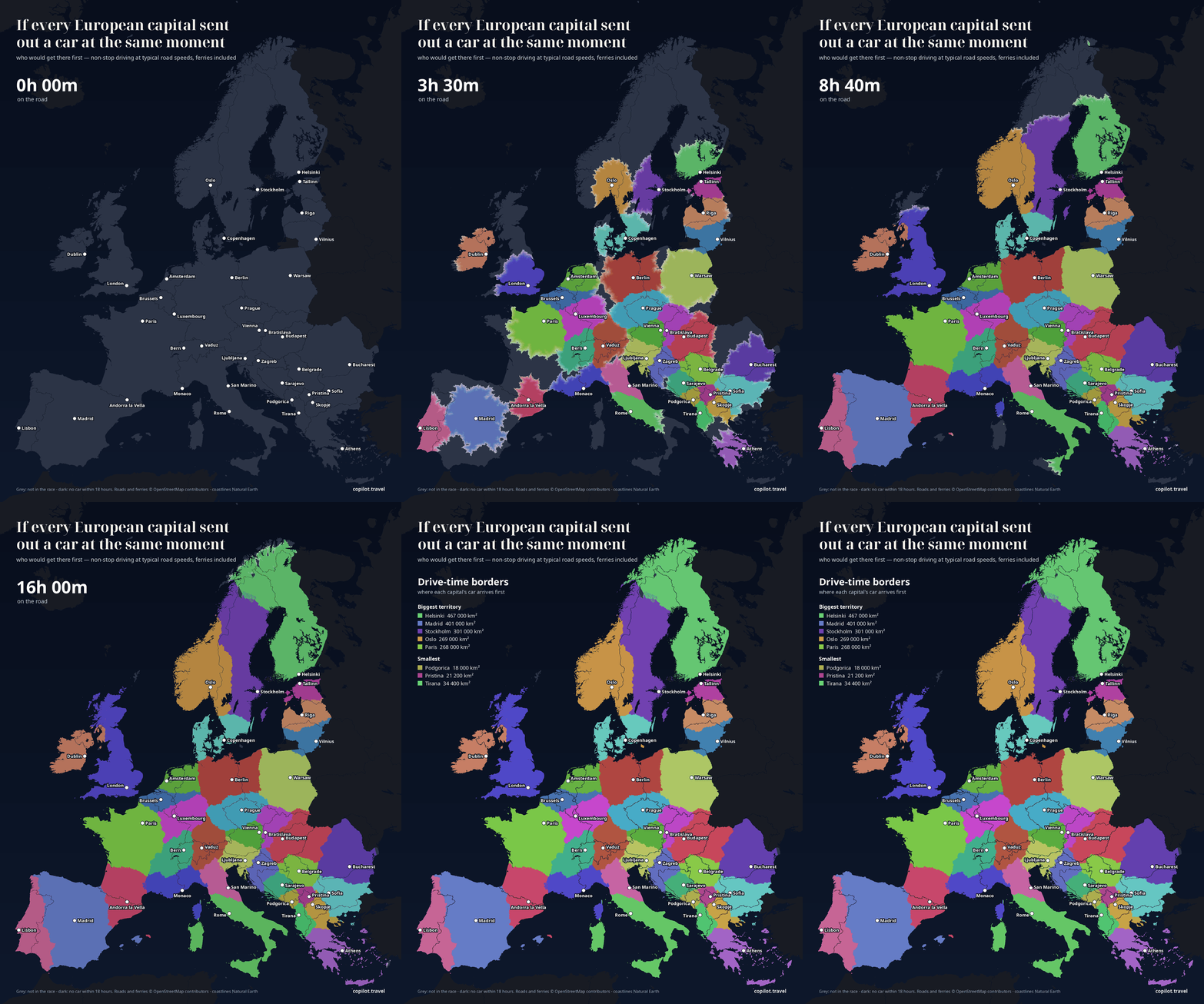
The race, hour by hour
Press play, drag the hours, tap a place to see whose car arrives first and who comes next, or pick one capital.
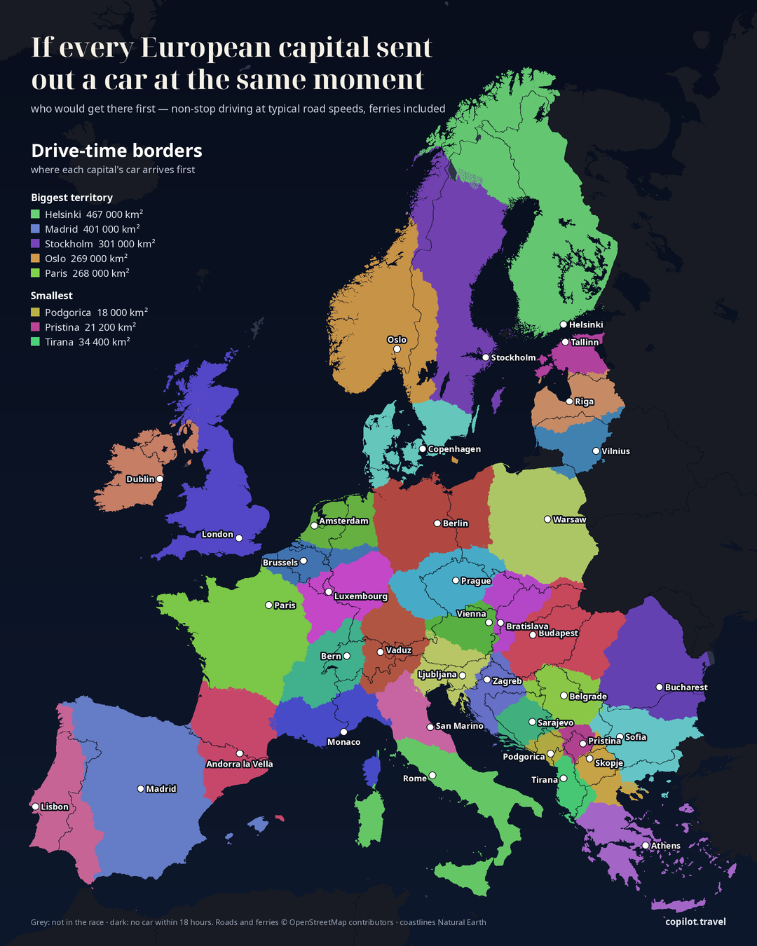
Who gets there first
Berlin's car reaches only 37 % of Germany first. The small capitals sit close to big cities in their neighbours: Liechtenstein's car is in Zürich before Bern's and in Munich before anyone else's; Monaco's takes Provence; San Marino's takes most of central Italy.
| Place | First there | Times |
|---|---|---|
| Munich | VaduzVaduz 2 h 25 · Prague 3 h 35 · Vienna 3 h 41 · Berlin 5 h 41 | Vaduz 2 h 25 · Prague 3 h 35 · Vienna 3 h 41 · Berlin 5 h 41 |
| Zürich | VaduzVaduz 1 h 04 · Bern 1 h 19 | Vaduz 1 h 04 · Bern 1 h 19 |
| Frankfurt | LuxembourgLuxembourg 2 h 19 · Amsterdam 4 h 30 · Berlin 5 h 23 | Luxembourg 2 h 19 · Amsterdam 4 h 30 · Berlin 5 h 23 |
| Barcelona | Andorra la VellaAndorra la Vella 2 h 43 · Madrid 5 h 28 | Andorra la Vella 2 h 43 · Madrid 5 h 28 |
| Marseille | MonacoMonaco 2 h 08 · Andorra la Vella 5 h 16 · Paris 6 h 38 | Monaco 2 h 08 · Andorra la Vella 5 h 16 · Paris 6 h 38 |
| Bologna | San MarinoSan Marino 1 h 16 · Rome 3 h 17 | San Marino 1 h 16 · Rome 3 h 17 |
| Malmö | CopenhagenCopenhagen 0 h 40 · Stockholm 5 h 38 | Copenhagen 0 h 40 · Stockholm 5 h 38 |
| Stranraer, Scotland | DublinDublin 4 h 53 · London 6 h 19 (the Belfast–Cairnryan ferry) | Dublin 4 h 53 · London 6 h 19 (the Belfast–Cairnryan ferry) |
| Brno | BratislavaBratislava 1 h 08 · Vienna 1 h 26 · Prague 1 h 45 | Bratislava 1 h 08 · Vienna 1 h 26 · Prague 1 h 45 |
| Kraków | WarsawWarsaw 2 h 40 · Bratislava 3 h 45 · Budapest 4 h 57 | Warsaw 2 h 40 · Bratislava 3 h 45 · Budapest 4 h 57 |
| Tromsø | HelsinkiHelsinki 15 h 19 · Stockholm 16 h 44 · Oslo over 18 h | Helsinki 15 h 19 · Stockholm 16 h 44 · Oslo over 18 h |
The territories, biggest first
Helsinki's car wins the most land — all of Finland, plus Lapland in Sweden and northern Norway, which it reaches before Stockholm's or Oslo's. Among the microstates, Andorra la Vella's car claims about 153,200 km², more than Greece; Monaco's about 94,500 km², roughly Portugal.
All 38 capitals
| Capital | Territory |
|---|---|
| Helsinki | 467,300 km² |
| Madrid | 400,700 km² |
| Stockholm | 301,000 km² |
| Oslo | 269,200 km² |
| Paris | 268,400 km² |
| London | 226,200 km² |
| Warsaw | 220,700 km² |
| Bucharest | 195,100 km² |
| Berlin | 189,000 km² |
| Rome | 161,400 km² |
| Budapest | 157,400 km² |
| Andorra la Vella | 153,200 km² |
| Lisbon | 137,700 km² |
| Prague | 120,800 km² |
| Sofia | 115,200 km² |
| Luxembourg | 108,600 km² |
| Vaduz (Liechtenstein) | 100,600 km² |
| Bern | 99,600 km² |
| Copenhagen | 97,500 km² |
| Monaco | 94,500 km² |
| Dublin | 94,100 km² |
| Athens | 91,800 km² |
| Riga | 76,000 km² |
| Belgrade | 74,000 km² |
| Ljubljana | 67,800 km² |
| San Marino | 66,300 km² |
| Amsterdam | 66,200 km² |
| Bratislava | 65,800 km² |
| Vilnius | 61,300 km² |
| Zagreb | 58,900 km² |
| Brussels | 57,100 km² |
| Vienna | 52,500 km² |
| Skopje | 46,600 km² |
| Sarajevo | 42,700 km² |
| Tallinn | 40,900 km² |
| Tirana | 34,400 km² |
| Pristina | 21,200 km² |
| Podgorica | 18,000 km² |
How much of its own country each capital wins
| Country | Own capital | The rest, first reached by |
|---|---|---|
| Germany | 37 % | Luxembourg 17 % · Prague 14 % · Vaduz 13 % · Amsterdam 10 % · Brussels 4 % · Copenhagen 2 % · Bern 2 % · Vienna 1 % |
| France | 49 % | Andorra la Vella 18 % · Bern 12 % · Monaco 12 % · Luxembourg 7 % · Brussels 2 % |
| Italy | 53 % | San Marino 22 % · Monaco 10 % · Vaduz 7 % · Ljubljana 6 % · Bern 2 % |
| Austria | 53 % | Ljubljana 28 % · Vaduz 16 % · Bratislava 3 % |
| Switzerland | 57 % | Vaduz 43 % |
| Slovakia | 58 % | Budapest 43 % |
| Sweden | 60 % | Helsinki 16 % · Oslo 14 % · Copenhagen 10 % |
| Norway | 63 % | Helsinki 26 % · Stockholm 11 % |
| Bosnia and Herzegovina | 66 % | Zagreb 23 % · Belgrade 7 % · Podgorica 4 % |
| Greece | 66 % | Sofia 15 % · Skopje 14 % · Tirana 5 % |
| Croatia | 69 % | Ljubljana 9 % · Belgrade 9 % · Sarajevo 9 % · Budapest 3 % |
| Serbia | 70 % | Pristina 12 % · Sofia 9 % · Skopje 4 % · Sarajevo 3 % · Podgorica 1 % |
| Poland | 71 % | Berlin 18 % · Prague 5 % · Bratislava 3 % · Budapest 2 % · Vilnius 2 % |
| Czechia | 71 % | Bratislava 25 % · Vienna 4 % |
| Romania | 72 % | Budapest 22 % · Belgrade 5 % |
| Bulgaria | 76 % | Bucharest 24 % |
| Spain | 78 % | Lisbon 11 % · Andorra la Vella 11 % |
| Belgium | 80 % | Luxembourg 20 % |
| Lithuania | 82 % | Riga 18 % |
| Netherlands | 82 % | Brussels 18 % |
| Hungary | 84 % | Bratislava 9 % · Zagreb 5 % · Vienna 1 % |
| Slovenia | 88 % | Zagreb 12 % |
| Albania | 88 % | Podgorica 7 % · Pristina 4 % |
| Montenegro | 90 % | Sarajevo 6 % · Pristina 5 % |
| North Macedonia | 90 % | Tirana 8 % · Sofia 1 % |
| United Kingdom | 91 % | Dublin 9 % |
| Portugal | 91 % | Madrid 9 % |
| Estonia | 92 % | Riga 9 % |
| Latvia | 93 % | Vilnius 7 % |
| Kosovo | 94 % | Skopje 6 % |
| Denmark | 99 % | Oslo 2 % |
| Andorra | 100 % | — |
| Finland | 100 % | — |
| Ireland | 100 % | — |
| Liechtenstein | 100 % | — |
| Luxembourg | 100 % | — |
| Monaco | 100 % | — |
| San Marino | 100 % | — |
Questions and answers
Answered from this page's own data, as of 25 October 2026.
Why does a tiny country win so much land?
The race starts from each capital's location, not from the size of its country. Vaduz sits between Zürich, Munich and Stuttgart, so Liechtenstein's car reaches about 101 000 km² first — more than all of Austria.
Are traffic, breaks or speed cameras counted?
No. Every car drives non-stop at typical road speeds with no traffic, and the same rules hold for all 38, so the borders compare like with like. A real trip with breaks takes longer everywhere.
How are ferries counted?
At their sailing time with no waiting at the port, which flatters island crossings a little. That is how Dublin's car, crossing Belfast–Cairnryan, reaches south-west Scotland before London's.
Why are Kyiv, Minsk and Ankara missing?
Ukraine, Belarus, Moldova, Russia and Turkey were not in this run, nor Iceland, Malta and Cyprus. They are drawn grey. Vatican City is left out because its car would tie with Rome's.
How exact are the areas?
The map uses an equal-area projection, so a territory's size on the map is its size on the ground; areas are rounded to the nearest 100 km². Places no car reaches within 18 hours (Shetland, some small islands) are drawn dark and not counted.
Method, data and caveats
- For each of 38 capitals, the drive time to every point on the road network, non-stop at typical road speeds with no traffic; ferries at their sailing time with no waiting. Each place goes to the capital whose car arrives first.
- Every capital ran until a check proved it could win nothing further: along the edge of its run, a rival had already arrived before it. Places past every edge — no car within 18 hours — are drawn dark.
- Off-road land between roads takes the time of the nearest road plus a short walk-in; cells with physically impossible times (faster than 150 km/h as the crow flies) were dropped.
- Roads and ferries © OpenStreetMap contributors. Coastlines and borders: Natural Earth. Equal-area projection (centred 52° N 10° E).